Saturday, September 06, 2008

Southern U.S. Awaits Hurricane Ike


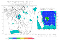
Tropical storm system Number 5- Category-3 Hurricane Ike- will threaten Florida and the U.S. Gulf coast next week.


Here are some visible satellite photos of Ike through today- and the latest hurricane track forecast by the National Hurricane Center in Coral Gables- FL.

_____________

K.C. MetroRegion BREAKING NEWS: Fatal Wreck In Leavenworth County-KS


One person has died and a 27-year-old male is in critical condition after a reported 2-vehicle wreck on U.S. 73 north of Leavenworth.


The wreck was reported to LVCO authorities at 6:05am at a location reportedly 2 to 3 miles north of Leavenworth.

One victim died at the scene and the driver of the 2nd vehicle- reported by EMS as "a 27-year-old male" was transported to a K.C. trauma center in very critical condition.

Considerable ground fog was reported at the scene by first-responders- but it's not known if that contributed to the crash.


__________

Proof Again That MAST-EMS Understaffs The City


For more than 15 years- I have contended that MAST-EMS- the ambulance/paramedic servicing Kansas City and several smaller Missouri suburbs- does not staff enough units to adequately cover the city.

This Saturday morning from 3 to 3:30am- there were no less than FOUR (4) calls in KC-MO that required EMS units from other municipalities to run in place of MAST- who had no units available to run them.

There were no major incidents occurring at the time and no extenuating circumstances.

Three of those mutual-aid EMS calls went to Johnson County-KS's MEDACT- the other went to Claycomo-MO's EMS.

As far as is known- no patients died as a result of an extended response time from those outside agencies- but one MAST-EMS unit responding to a stabbing on KC-MO's East Side took 15 minutes after the initial 3:11am dispatch time to arrive on that scene.

What do I consider adequate staffing?

Cities such as Grandview and Raytown-MO have at least 2 in-service EMS units for their approximately 30000 residents. Using a rule of thumb of 1 EMS unit per 20000 residents- MAST should have a minimum of at least 22 units in service for the estimated 460000 residents in their service area.

I have never logged more than 18 EMS units in service overnight at ANY given time in KC-MO since I began monitoring for Kansas City news media in 1991.

I have brought this to the attention of the news media outlets that have employed my services to no avail.

Granted this issue is not as "juicy" as things such as the alleged acts of the mayor's wife- perhaps someone dying due to lack of prompt EMS service will bring this seemingly more important and on-going issue to the local news media's attention.
___________

Thursday, September 04, 2008

Hurricane- Tropical Storm- Tropical Depression Gustav Rain Totals


The rain from the remains of Gustav has ended in Metro Kansas City- and over much of the MetroRegion as well.


Here is a Metro storm-total radar-indicated precipitation amounts image from the NWS-Topeka (click-on for full size):


SELECTED STORM TOTAL RAINFALL AMOUNTS IN INCHES THROUGH 1 PM CDT
THURSDAY...UNLESS OTHERWISE INDICATED:


...LOUISIANA...

FRANKLIN 20.00
GRAND ISLE 19.19
LARTO LAKE 19.00
HAHA BAYOU JONESVILLE 7 SW 18.87
NE BAY GARDENE NR POINT A LA HACHE 17.76
JONESVILLE 7 SW 17.70
FOOLS RIVER CLAYTON 4 NNW 17.58
WINNSBORO 5 SSE 16.51
BUNKIE 0.3 WSW 16.37 THROUGH 7 AM CDT WED
MISSISSIPPI SOUND AT GRAND PASS 14.84
CLAYTON 4 NNW 14.54
BUNKIE 14.06
RAYVILLE 13.91
RED RIVER LOCK AND DAM 13.50
BAYOU COCODRIE NEAR CLEARWATER 13.88
COMO 13.24
CLEARWATER 12.54
DELTA COMMUNITY COLLEGE 11.95
OAK RIDGE 11.79
BASTROP 3.2 NNE 11.55
BAYOU DES GLAISES AT MOREAUVILLE 11.16
WEST MONROE 4.1 NW 10.98
ALEXANDRIA 9.50
MONROE 9.43
BATON ROUGE 4.81


...MISSISSIPPI...

LAKE WASHINGTON TRIB NR CHATHAM 12.40
UNION CHURCH 11.93
GLOSTER 11.74
BUDE (HOMOCHITTO NATIONAL FOREST) 11.53
HAMBURG 11.25
GREENVILLE 11.09
VICKSBURG 10.75
ROLLING FORK 16.1 WSW 10.56
LIBERTY 6.4 ENE 10.27
STONEVILLE 1 NE 10.26
HOMOCHITTO RIVER AT EDDICETON MS 9.34
CENTREVILLE 9.33
BUFFALO RIVER NEAR WOODVILLE 9.25
VICKSBURG 10.1 NNE 9.06
MISSISSIPPI RIVER NEAR GREENVILLE 8.81
MCCOMB 7.59
OAKLEY 7.45
HATTIESBURG 6.42
PASCAGOULA 4.61
BILOXI/KEESLER AFB 4.10


...ARKANSAS...

EUDORA 11.90
BAYOU MACON AT EUDORA 11.74
BISMARCK 11.50
LEOLA 11.26
WHITTINGTON CREEK AT HOT SPRINGS 11.12
FELSENTHAL OUCHITA RIVER 11.00
JACKSONVILLE 10.90
LITTLE ROCK AFB 10.82
HAMPTON 10.65
WARREN 10.33
BENTON 10.26
MORO BAY 10.15
CROSSETT 2 SSE 10.10
MARCHE 9.89
AMITY 9.67
FOURCHE CREEK UNIVERSITY AVE 9.58
MALVERNE 9.57
UNIVERSITY OF AR MONTICELLO 9.51
CENTER RIDGE 4 S 9.27
REMMEL DAM TAILWATER 9.25
ANTOINE 9.23
ARKADELPHIA 9.01
CLEVELAND 9.00
MAUMELLE RIVER AT WILLIAM JUNCTION 8.94
WALTREAK 8.58
HOT SPRINGS 8.14
LITTLE ROCK (LIT) 6.40
FORT SMITH 5.72
TEXARKANA 5.09


...MISSOURI...

JACK FORK AT ALLEY SPRING 11.62
VANDALIA 9.91
MORGAN 1 SE 8.90
ALLEY SPRINGS RANGER STATION 7.91
FORSYTH 1.9 SW 6.98
CHAIN O LAKES 2.0 NE 6.60
REYNOLDS 6.60
EAGLE ROCK 1.5 SW 6.47
BUNKER 4.4 N 6.27
MYRTLE 6.25
SINKIN 6.14
CASSVILLE 0.5 SW 6.03
EL DORADO SPRINGS 0.6 NNW 6.00
PLAD 1 E 5.80
LEBANON 1 E 5.79
WEST PLAINS 3 SW 5.30
JOPLIN 4.93
FT LEONARD WOOD 4.13
SPRINGFIELD 3.48


...OKLAHOMA...

SPIRO 6.17
MCCURTAIN 5.25
KINGSTON 2 S 5.23
NEOSHO RIVER NEAR COMMERCE 4.70
WISTER 3 S 4.28
VINITA 2.95
BUNCH 0.8N 4.38
TAR CREEK AT MIAMI 2.41
BIG CABIN CREEK NEAR BIG CABIN 2.33
DAVIS FIELD 2.07
MUSKOGEE 2.03
MCCALESTER REGIONAL AIRPORT 1.72


...TEXAS...

TEXARKANA 10 SW 2.60
MARSHALL 15.2 SE 1.73
PARIS 1.07


...KANSAS...

PITTSBURG 0.7 WSW 3.91
SPRING RIVER NEAR BAXTER SPRINGS 3.77
CHEROKEE 0.3N 3.50
MCCUNE 1.6 NW 2.49
GIRARD 3.1 SSW 2.41
STRANGER CREEK NEAR POTTER 2.30
PLEASANTON 0.3 SSE 2.18
CHANUTE 1.83

...ILLINOIS...

ILLINOIS RIVER AT RIPLEY IL 4.30
ILLINOIS RIVER AT MEREDOSIA IL 3.28
PARIS (WATER WORKS) 3.00
ARKANSAS RIVER NEAR LARNED KS 2.49
PITTSFIELD 2.24
QUINCY 1.98

...IOWA...

MISSISSIPPI RIVER AT BURLINGTON 2.27
COLUMBIA 2.01
RATHBUN DAM 1.94
CENTERVILLE 0.5 SE 1.42


...TENNESSEE...

MUNFORD 6.8 WNW 2.45
MEMPHIS (MEM) 2.05

...MICHIGAN...

JACKSON 1.2 ENE 1.74
HANOVER 3.8 W 1.54
HUDSON 3E 1.54

...FLORIDA...

PENSACOLA NAS (NPA) 4.12
PENSACOLA (PNS) 2.14
DESTIN 2.08
MARATHON 2.04
KENDALL-TAMIAMI (TMB) 1.92


...ALABAMA...

ROBERTSDALE 5 NE 7.56
FAIRHOPE 2.3 N 5.59
MOBILE BROOKLEY FIELD (BFM) 3.10
MOBILE (MOB) 2.30


RAINFALL AMOUNTS OF 1 TO 3 INCHES ARE EXPECTED FROM NORTHERN
ILLINOIS INTO PORTIONS OF SOUTHEASTERN WISCONSIN... NORTHWESTERN
INDIANA AND MICHIGAN WITH ISOLATED MAXIMUM AMOUNTS OF 5 INCHES
THROUGH SATURDAY MORNING. ADDITIONAL RAINFALL AMOUNTS NEAR AN INCH
WITH MAXIMA OF 2 INCHES ARE EXPECTED ACROSS FAR SOUTHEASTERN
LOUISIANA... SOUTHEASTERN MISSISSIPPI AND WESTERN ALABAMA THROUGH
THIS EVENING.


___________

Gustav Rains


There has been just about 3.7-inches of rain here in southeastern KC-MO since 4pm Tuesday- compliment of once-Hurricane Gustav.


No flooding problems locally- so thanks Gus!

__________

Volunteers For KC-MO City Government Should Boycott


Maybe a council person or two should be recalled as well- since they're so intent on passing some idiotic ordinance regarding city volunteers.


It's a knee-jerk reaction to charges- a "she-said- she-said"- brought against Mayor Funkhouser's wife- who allegedly called a staffer a name.

Allegedly a name that's not even one of the late George Carlin's "seven deadly words."

This is typical guilty until proven innocent 21st Century American law.

I'm still pissed at the city council overturning the light rail initiative the voters passed.

Perhaps it's time for this Libertarian Party committeeman to start a recall petition of the council members who overturned the results of that election.

After all- what's good for the goose- et cetera....

____________

Wednesday, September 03, 2008

Metro Tornado Warning Siren Test On-Schedule Today


At 11am- the scheduled monthly test of Metro K.C. tornado warning sirens will be conducted as usual- so says the NWS-Pleasant Hill office minutes ago.


"We're not expecting any severe weather today- and the heavy rain and flooding issues will be later tonight (overnight)"- the NWS spokesperson said.


Therefore- don't be alarmed when you hear the sirens going off in less than an hour.....


_________

Kansas City MetroRegion WEATHER: Excessive- Flooding Rains Nearby


The remains of Hurricane Gustav and a frontal system will combine to produce excessive rainfalls along with flash and general river flooding through Thursday over about the southeastern half of the Kansas City MetroRegion.

Flash flood and general flood watches are in effect for most of the southeastern 4/5ths of Missouri today.

Metro Kansas City will be very close to these tropical rains- with some areas receiving more than 2-inches yesterday (2.2-inches here in Southeastern KC-MO)..

Of special concern will be southern Miami & northern Linn counties in Kansas- where more than 3-inches of rain has fallen since yesterday evening.

__________

Experience And Morals No Longer A Republicrat Selling Point

Experience?

Careful knocking-on Barrack Obama since you have "Has ANYBODY Ever Heard Of" Palin.
Her running mate is not exactly a domestic OR foreign policy whiz and has- by his own admission- little knowledge of economics (and he owns 7 houses????).

Morals? Family values?

The Republicrats better tread VERY lightly here as we watch the minor- unmarried & pregnant daughter of their vice presidential candidate's abdomen balloon.

This Greedy Old Party has shot itself in the collective foot- for they SURE can't run on the accomplishments of the present incumbent.

The Republicrats therefore will heavily rely on their Karl Rovian-inspired 3rd-party political ads this year.

You WON'T hear McCain at the end of those ads approving the messages- but rest assured he will be knowlegable of their purpose and content.

Being a Libertarian- I'm certainly no fan of the Demublicans- but the past 8 years under Republicrat rule have been utterly disasterous for America.
_________

Tuesday, September 02, 2008

K.C. Metro WEATHER: Wet To Dry Contrast Areawide


Scattered showers and thunderstorms continue to develop and move generally south to north across western to northern areas of Metro Kansas City.

Shown below is a Doppler radar-indicated map of precipitation that has fallen over the area this Tuesday afternoon.
Using the color key on the left of the image- the warmer-colored areas of around 2-inch rainfalls are indicated in southern Platte county MO- mainly in the Line Creek watershed.

Caution should be used around creeks and drainage ditches in southern Platte county for at least the next several hours as additional storms with heavy rain are likely over these same areas.

__________

K.C. Metro WEATHER: Showers- Thunderstorms Developing


The activity shown continues to increase in intensity and coverage as it moves north-northwestward over the area- fueled by a cool front interacting with the remains of now-Tropical Depression Gustav..


No organized severe weather is expected or forecast- although some heavy storms are likely with very heavy rainfalls.

__________

Oil Company Gouge Continues: Oil Below $110-Barrel - Gas Above $3.50-Gallon


As of this posting- the price of a barrel of oil is BELOW $110- yet gasoline prices remain high.


To compare- when barrel-oil prices were around $110 earlier this year- the price of gasoline was around $3-3.10 per gallon.

So why are we STILL paying more than 50-cents more per gallon compared to that time the price of a barrel of oil was the same as today?
Greed. Calls to several "free-press" outlets provided no answers- nor any promises of inquiry.

Have the oil companies bought the American "free" press too?

Ask yourself when (if) you vote in November one question:

Are you and your family better off financially than you were 1, 2, 3 or 4 years ago?

_________

Why Do TV Weatherpeople Ask The Viewers Questions

Everyone's the tease anymore- and this ilk has ingrated itself into local newscasts.

You've seen it- when the weatherperson comes on to tell you to watch their upcoming segment.


What's worse is when that weatherperson asks us- the viewers- weather questions:


"Is it going to (fill in the blank) tomorrow?"


Why the Hell are they asking US? Aren't THEY supposed to provide the weather answers?


I've solved this problem by shutting off the TV- firing up the computer- finding out the answer- and emailing it to the appropriate weather-questioner.


Reason No. 27 why local news is fighting to get/keep a 20-share audience of viewers when more than 25 years ago they had 30+-shares.


________

Gustav Slowly Dies- Hanna Threatens


Gustav has become a tropical depression- but still threatens to drop excessive rains in the mid to lower Mississippi Valley.

The Kansas City MetroRegion will be affected by the remains of Gustav interacting with a cool front later today into Thursday.

Here is a visible satellite photo showing Gustav in the mid-upper left and Hanna on the lower right of the image.

Now of concern is Tropical Storm Hanna- located east of the Bermudas. Hanna is pegged by weather models to become a hurricane before it slams into the Southeastern U.S. Atlantic coast later this week.

Shown here are some of the operational weather models that specialize in hurricane predicition (click on all images here for full resolution).

These are the GFDL and HWRF models- shown side by side during the same time intervals- from the 1am CDT model initiation.


Note that the GFDL has Hanna more than 20 knots stronger- but both show a landfall either on or between Jacksonville-FL to Charleston-SC- by later this week.
__________

Jackson County Taxpayers Didn't Read The Fine Print


Many people are up-in-arms over the Chiefs (Chefs) selling the naming rights to Arrowhead Stadium.


That's right- that football stadium- built- maintained and yes- OWNED by the Taxpayers of Jackson County- Missouri.

Apparently- they didn't read about the deal the Jackson County Sports Authority made with the 2 "pro(?)" teams when a majority of voters agreed to shovel taxpayer money to them a couple of years ago.

Among the concessions made were allowing the Chefs (inept) management to sell the naming rights to Arrowhead and keeping all the profit.
That's just one reason why the Captain and all the voters in this household voted AGAINST that taxpayer subsidy for multi-millionaire "pro(?)" team owners and their employees.

We managed to READ that fine print- hidden among the cheerleading stories published and aired by Kansas City's "free (not) press" when it came time to examine then vote on that issue.

People shouldn't be surprised therefore- for things like sold naming rights and the shoddy leadership in this country.

Voters buy into scare tactics- like what our "free press" employed to promote that taxpayer subsidy (to be fair- most of that was drummed up by corporate-press column writers under the guise of "editorial.")

Most voters will vote that way again in November. Issues and platforms of the candidates will be a distant second to whether a voter "likes" that candidate or not or is glued to voting along party lines.

So here's a novel idea: Disregard free-press biases and cheer leading and BEFORE you vote on an issue or a candidate- try EDUCATING yourself on what that issue or candidate entails FIRST.

Perhaps then it won't come as some sort of revelation that you were sold a pig in a poke. Or the property you own is taken over by some tenant.

___________

Sunday, August 31, 2008

Hurricane Gustav Satellite Photo Time Series


Although Hurricane Gustav had weakened to a Category-3 storm- Gustav is expected to strengthen again.


However- NO hurricane model forecasts expect Gustav to reach Category-5 status at this time.

Here is a series of medium and high-resolution satellite pix of Gustav- starting around 11:30am Central Daylight Time (click on each image for full-size).

The same coordinates were used to facilitate viewer copies of these images for animation purposes- images courtesy of NASA.

NOTE: Times shown on the images are UTC (Universal Time Coordinated) subtract 5 hours for Central Time.

Hurricane Gustav is forecast to make landfall late Monday (Labor Day) somewhere near Vermillion Bay in Louisiana as a Cat-3- possibly a Category-4 hurricane.

____________

Flooding Rains Will Be A Major Gustav Concern


Along with the usual threats with a Category-4- possible Category-5 hurricane- Gustav and his slow movement once he gets inland will produce tremendous rainfall amounts.


Here are one weather model estimates of rainfall along Gustav's path through a 7-day period.

The red areas are 40-centimeters or amounts of rain greater than 15-inches.

These flooding rains will be found from northeast to southeast of the center of Gustav's landfall- probably over Mississippi- parts of Louisiana and Arkansas.

______________

Will Republicrats Party While New Orleans Drowns

We will see.
__________

Tornado Strikes Monroe LA With Confirmed Injuries

The tornado struck around noon on Easter Sunday. There is considerable damage repo rted in that northeastern Louisiana city of around 5000...